NASA Needs Your Help Identifying Pictures Of Cities At Night
Think you know what your city looks like from the sky? Help NASA identify and classify nocturnal images from the ISS
If you’ve lived in a city for any length of time, you’re probably become accustomed to its layout, and even at night, you can identify its major roads and layout from the city lights. Now NASA needs your help to put that knowledge to good use as part of its Cities By Night project.
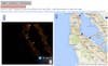
NASA has a trove of more than a million images taken from the ISS at night, and it needs the help of citizen scientists to correctly identify what’s going on in the countless photos that need processing. The first step is to help out with the Dark Skies task—where you can help correctly spot if an image is of stars, a city, aurora, or something else.
Then comes locating the city. You can click on a dot on a map for the geolocation of the ISS at a specific point, and then compare the image taken then with Google Maps to try and identify what the city it’s looking at is. Finally, there’s georeferencing the cities—matching up specific points on a map to points on the photo, so that NASA knows exactly how the two line up.
What’s the point in all of this? It’s at least partly a move to help map the light pollution of these cities. As the site explains: “
So if you feel like helping out NASA by scoping out some images of your city, here’s a chance to help.