The Photo As Evidence: Wildfires from Space
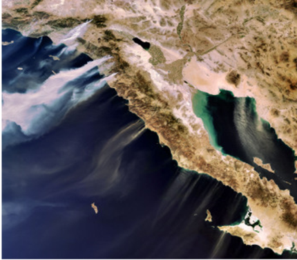
I found these satellite images of California on Wired News. It's a different perspective on the wildfires than we see on television, showing how big this inferno is, and what firefighters are up against. Here you see a portion of California near San Diego and part of Baja California. The smoke trails are the white ones; the brown trails are actually sand being blown out to sea by the Santa Ana winds. The image was made on Monday by the European Space Agency's Envisat satellite.--David Schonauer
I found these satellite images of California on Wired News. It’s a different perspective on the wildfires than we see on television, showing how big this inferno is, and what firefighters are up against. Here you see a portion of California near San Diego and part of Baja California. The smoke trails are the white ones; the brown trails are actually sand being blown out to sea by the Santa Ana winds. The image was made on Monday by the European Space Agency’s Envisat satellite.
–David Schonauer