Flickr’s Geofences Offer More Privacy With Geotagged Photos
You can now customize the amount of GPS data Flickr shares to your profile
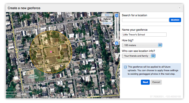
Geofences is a new feature from Flickr designed to add some privacy controls to geotagged pictures, allowing you to set up who can see location information based on where the photograph was taken. All it takes is drawing a circle on the map, and then setting who on Flickr can see the GPS information for photographs you’ve taken inside that area. From then on if you snap an image inside the circle, that data will only be shared with groups you’ve okayed to see it.
Users can have up to 10 Geofences, which cover areas up to 10km wide. Don’t want people knowing your address from the photographs you take in your back yard? Stick a Geofence over a city block or three to keep it covered. Anything not taken inside a Geofence will just be uploaded as per your default settings.
Once you have Geofences set up, they’ll apply retroactively to all your uploaded images.
For a more detailed explanation of how the service works, check out Flickr’s code blog which delves into the nitty gritty about how the circles work in a bit more detail.
What most people just need to know is that this is a powerful and straightforward way of controlling who can see your location in areas that you might want to keep private.