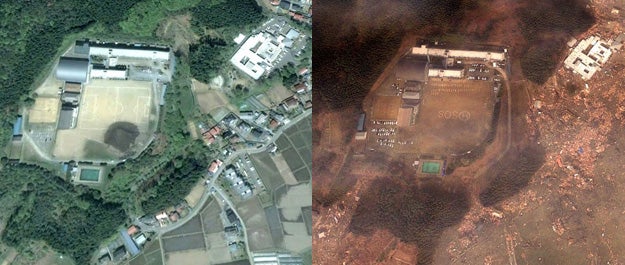
Japan Tsunami Before and After
via Google.
SHARE
Google Satellite Japan main

Google Satellite Japan main

For those who aren’t experiencing Japan’s current tragedy first hand, it’s kind of hard to really take in the scope of the whole situation. But, some images pulled from Google’s satellite help us visualize exactly how catastrophic this whole event has been.

Coastlines have been drastically changed and entire sections of land have been overrun with water that has brought with it dirt and debrit.

They have put the entire high-res collection up on Picasa for users to look through. They’re incredibly powerful and amazing at the same time.

minamisanriku 2002.jpg
Minamisanriku in 2002.
minamisanriku after.jpg
Minamisanriku after the tsunami. Google
sendai airport 2003.jpg
Sendai airport in 2003. Google
sendai airport after.jpg
Sendai Airport after tsunami. Google
minamisanriku sos 2002.jpg
Soccer field in Minamisanriku in 2002. Google
minamisanriku sos after.jpg
SOS on soccer field in Minamisanriku after the tsunami. Google
ofunato rikuzentakata border coast 2005.jpg
Area of border between Ofunato and Rikuzentakata in 2005. Google
ofunato rikuzentakata border coast after.jpg
Area of border between Ofunato and Rikuzentakata after the tsunami. Google
google_japan_11.jpg
Fujitsuka in Sendai in 2008. © 2011 Google, DigitalGlobe 2008年 宮城県仙台市若林区藤塚 © 2011 Google, DigitalGlobe
google_japan_12.jpg
Fujitsuka in Sendai after tsunami. © 2011 Google, GeoEye 被災後 宮城県仙台市若林区藤塚(現地2011/3/12 撮影) © 2011 Google, GeoEye
google_japan_9.jpg
Yuriage in Natori in 2008. © 2011 Google, DigitalGlobe 2008 年 宮城県名取市閖上 © 2011 Google, DigitalGlobe
google_japan_10.jpg
Yuriage in Natori after tsunami. © 2011 Google, GeoEye 被災後 宮城県名取市閖上(現地2011/3/12 撮影) © 2011 Google, GeoEye